
Visual verification · Working with historical panoramas
Street View history for OSINT: date the visible change, not the whole story
A business says its shop opened in 2021. Street View shows the name above a green awning. Useful evidence? Possibly. First check which panorama you are looking at, when it was captured and whether you have found the right doorway.
Historical Street View can help compare a public place across available captures. It can show that a sign or entrance looked a certain way in a dated image. Several captures may narrow a change to an interval. They do not, by themselves, establish an opening day, uninterrupted trading or who legally occupied the building.
Get into a panorama before comparing dates
On a computer, open the location in Google Maps and use Pegman to enter Street View. Where available, choose See more dates and select an older capture from the thumbnails. Google notes that historical imagery is not available everywhere. Its Street View instructions describe the controls. Google Earth also offers historical Street View, with available dates and a return-to-latest control.
A business listing’s photo gallery is not the same object as a street panorama. Before using a date, identify the source of the image you actually opened. In Google Earth, the imagery documentation describes a month-and-year collection date for Street View panoramas. Preserve the date as displayed; do not turn a month into an invented day.
Google’s Street View imagery policy also makes clear that these images are not live. The date you open the map is your access date, not the date of the scene.
Choose anchors that survive a new sign
Start with two or three features unlikely to depend on the business name: the arrangement of upstairs windows, a brick arch, a neighbouring doorway or a drainpipe. Use them to line up the older and newer views. A pin or a familiar sign alone is a weak anchor, especially in a row of similar shops.
Now identify the exact area you need to see. Is it the fascia above the door, the front window or an entrance around the corner? A wide view may establish the building while being too blurry to read the sign. Keep those as separate judgments.
After moving along the street or selecting another panorama, check the displayed date again. Your evidence belongs to the selected view. Also note direction and obstruction: a tree, open shutter or delivery van can hide the feature you are trying to compare. “Not visible” deserves its own category.
If you have not yet established the location, start with the image geolocation method. Date comparison becomes useful after you know you are comparing the same place.
The green-awning exercise
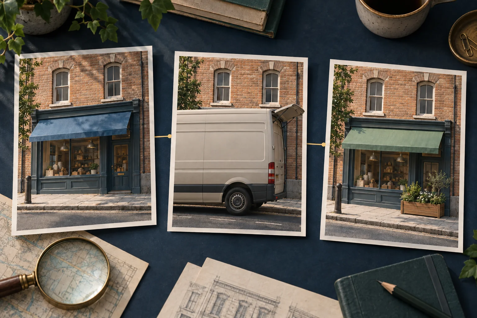
This is a fictional training scene. You are checking a claim that a bookshop’s green awning was already installed in 2021. The brick arch and two narrow upstairs windows match across three captures.
| Displayed capture date | What the relevant area shows | What you can write |
|---|---|---|
| May 2019 | A clear blue awning above the same entrance. | The green awning is not present in this view. |
| August 2021 | A delivery van and its raised loading door obscure the awning. | The awning’s state cannot be determined from this view. |
| June 2023 | A clear green awning and a planter beside the door. | The green awning is present in this view. |
The 2021 claim remains unresolved. The two clear images show different states, but the middle image cannot decide which state existed then. A careful finding is: “The available views show a blue awning in May 2019 and a green one in June 2023; the August 2021 view does not resolve the installation claim.”
Under the assumption that these views track the same continuous change, the alteration happened between the two clear observations. But the pictures do not exclude an awning being replaced twice, removed temporarily or repainted. State that assumption if the precise sequence matters.
Now change one fact: imagine the August 2021 view clearly shows the green awning. You could support its presence by that capture, still without knowing the installation day. The exercise is about the strength of an observation, not choosing the most persuasive-looking image.
Keep appearance, activity and occupancy apart
A sign can remain after a business leaves. A shutter can be closed on a normal trading day. A newly painted front does not tell you when a lease began. Decide which of these questions you actually need answered before collecting more panoramas.
For a claim about a public opening event, a dated announcement or another contemporary source may help. For a registered address, use the appropriate official company record. For a map label change, the OpenStreetMap history guide explains why editing a map and changing a place are different events. These sources can complement an image; they cannot retroactively make a hidden sign visible.
Leave the next reader a reproducible view
Save the view link, displayed collection date, attribution, access date and a short description of the viewing position. If you use the service’s share function, reopen the saved link and check that it reaches the intended panorama and date. Describe the anchors and the part of the scene being compared so the link is not carrying the whole explanation.
For each observation, record one of three states: visible and present, visible and absent, or not assessable. Add the reason for the third state. Keep a contextual record where permitted, retaining the image’s attribution; an unexplained crop is harder to audit than a note that identifies its original view.
If the remaining task is to connect a visual change with a company’s public history, bring those dated observations to the OSINT Jet image investigation workflow. Specify the unanswered relationship, such as “Does independent evidence support this shop’s claimed opening period?” The useful result should distinguish what the pictures show from what other sources establish. One clear dated panorama may be enough for a narrow question; a wider case needs a wider evidence trail.
Published 8 October 2026 · OSINT Jet