
OSINT Jet · Image intelligence field guide
Image Geolocation Without EXIF: A Five-Pass OSINT Method
A photo can lose its GPS data and still keep hundreds of location clues. The trick is to stop asking, “Where does this feel like?” and start testing small, independent features: a traffic rule, a paving pattern, a transit sign, the slope behind a roof. This method narrows a public-place image without pretending that one familiar-looking object proves an exact address.
Decide how precise the answer needs to be
“Geolocate this image” hides four different tasks. You might need the country, the city, the street or the exact camera position. Write the required level first. Every extra level needs stronger evidence and creates more risk if you are wrong.
| Target | Evidence that may be enough | What is still unsafe to claim |
|---|---|---|
| Country or region | Compatible script, traffic side, road design and landscape. | A city based on one national feature. |
| City | A locally specific transit system, street furniture and map-compatible terrain. | A street because the architecture “looks right.” |
| Street | Several stable landmarks matching the same road geometry. | The camera position without checking orientation and viewpoint. |
| Viewpoint | Building order, angles, elevation and sight lines agree from the proposed spot. | Private occupancy or who took the photo. |
Use the least precise answer that solves the real problem. A city-level result can be complete even when the exact corner remains unknown.
Preserve the original before making crops
Keep the highest-quality lawful copy you received, along with its source URL, surrounding post, filename and retrieval time. Create working copies for enhancement and cropping. Never replace the original with an edited version.
Metadata is useful when it exists, but it is not a verdict. The CIPA Exif standard describes fields used to store image and capture information; platforms can remove those fields, editing software can rewrite them, and a file can be shared as a screenshot. Missing EXIF does not prove manipulation. Present EXIF does not prove the scene. See the current CIPA Exif standards for the technical specification.
ORIGINAL
Source URL | retrieval time | file hash | dimensions

WORKING COPY
Crop ID | coordinates | adjustment | purpose

CLAIM LIMIT
Country | city | street | viewpoint
If the only copy is tiny or heavily compressed, lower your expected precision before doing anything else.
The five-pass image geolocation method
Pass 1: source history before scene recognition
Reverse-search the full frame and two distinctive crops. Google Lens can search with an image; Google’s “About this image,” when available, can add context about when Google may first have seen similar versions and where else they appeared. These tools help trace versions, but a matching caption is still a lead to verify. Review Google’s guidance for searching with an image and About this image.
Ask whether an older upload contains a wider frame, original caption or higher resolution. Do not count five reposts of the same crop as five confirmations.
Pass 2: systems that repeat across a place
Look for the side of traffic, lane markings, curb paint, license-plate proportions, utility poles, pedestrian signs, transit colors and address formats. A language may cover several countries; a traffic system plus a script plus a plate shape eliminates more candidates.
Transcribe only characters you can actually see. Record uncertain letters with a placeholder instead of letting an OCR guess become your evidence.
Pass 3: built environment and street furniture
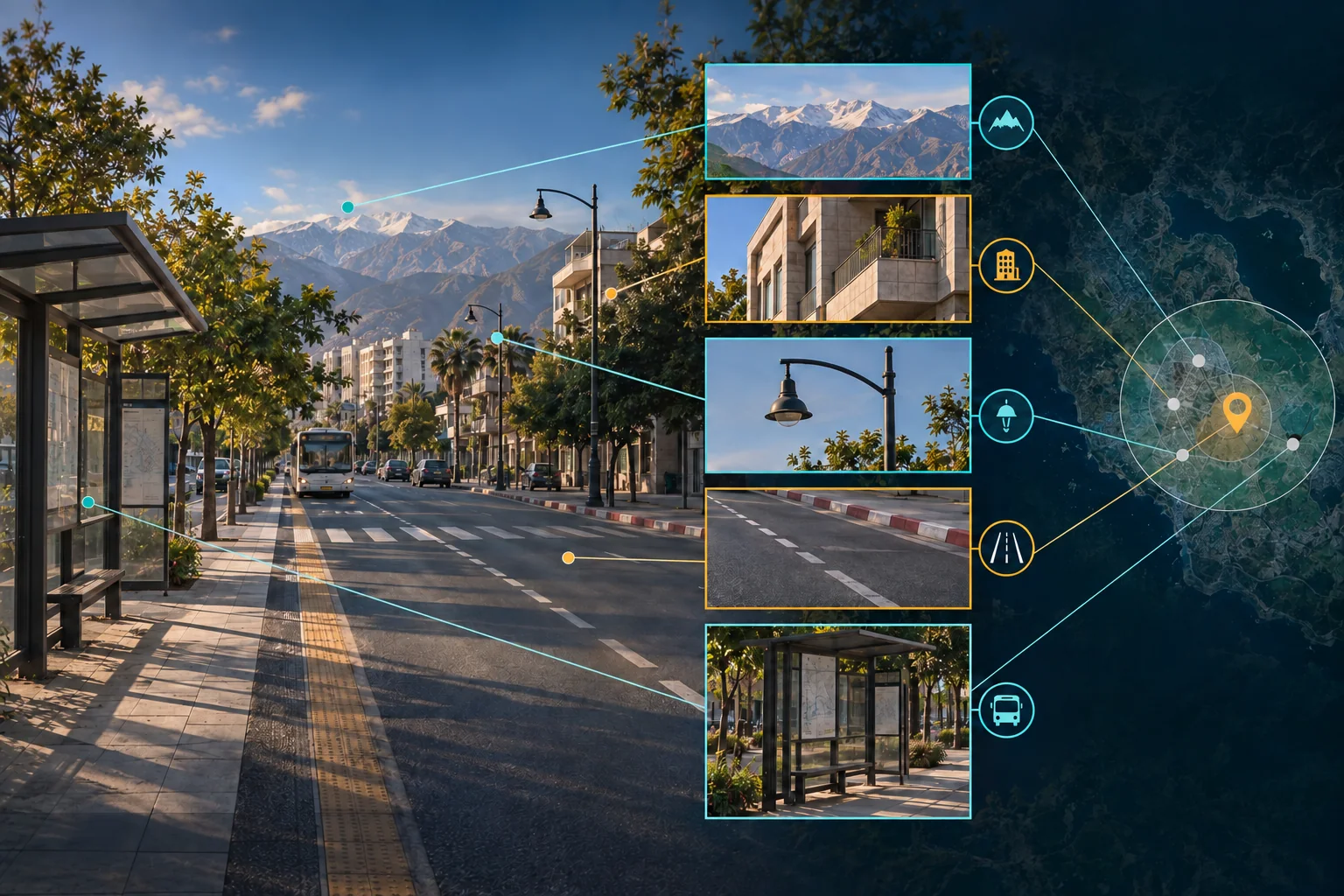
Compare roof material, balcony form, drainage, paving, bollards, lamp posts, bins and storefront mounting. Separate permanent features from temporary decoration. A festival banner may last a week; a tram-wire junction or retaining wall may last decades.
Search the distinctive object, not the whole imagined story. “Blue ceramic street plate with white border” is testable. “Mediterranean old town” is a mood.
Pass 4: terrain, vegetation, light and weather
Trace the skyline, slope direction, coast or river relationship, tree species group and shadow direction. Weather alone is weak because it changes by the hour. Terrain is stronger when road orientation and visible elevation agree on a map.
Avoid false precision from the sun. Without a reliable capture time and camera orientation, a shadow usually supports a broad direction, not a timestamp or exact latitude.
Pass 5: map comparison and the three-anchor rule
Turn your surviving candidate into a map hypothesis. OpenStreetMap documents searchable feature tags in its Map Features reference. Compare road bends, transit stops, waterways, elevation, plazas and building footprints using lawful map and street imagery available for the area.
Before naming a street, require three independent anchors in the same geometry. For example: the road curves left after the square; a tower appears behind the second roof; and a steep stairway rises opposite the stop. One shop sign can move. Three stable anchors that align from one viewpoint are harder to explain by coincidence.
Use a crop ledger so clues do not blur together
A crop ledger records what each image fragment was meant to test. It prevents you from remembering a promising search as a confirmed match.
| Crop | Visible clue | Search or comparison | Result | Alternative |
|---|---|---|---|---|
| C-01 | Transit sign: dark circle, pale horizontal bar. | Compare official city transit symbols among surviving candidates. | Compatible with Candidate B; inconsistent with C. | Private shuttle branding. |
| C-02 | Two-color stone fan pattern. | Municipal paving galleries and street imagery. | Appears in A and B. | Modern imitation used elsewhere. |
| C-03 | Ridge behind a low tiled roof. | Map terrain and candidate viewpoints. | Geometry agrees only in B from the west side. | Different ridge with similar outline. |
Write “inconsistent” and “not visible” as carefully as “match.” Geolocation often advances faster by eliminating candidates than by recognizing a place in one dramatic leap.
Worked example: narrowing a public square
This is a synthetic exercise. It does not show a real private location, customer case or OSINT Jet result. Imagine a daytime photo of a public square. There is no usable metadata and no readable business name. The target is city-level, not a doorway.
The first pass finds no earlier upload. The scene shows right-hand traffic, a Latin-script fragment, black-and-white wave paving, overhead transit wires, a blue stop marker and a steep green ridge west of the square. Initial research produces three candidates.
| Candidate | What fits | Contradiction | Decision |
|---|---|---|---|
| A | Paving pattern and language family. | No wired transit near the mapped central squares; terrain is flat. | Reject. |
| B | Transit symbol, wired route, paving family and ridge direction. | One lamp-post style differs in recent imagery. | Keep; check image dates and renovation records. |
| C | Green ridge and tiled roofs. | Transit logo and road markings are incompatible. | Reject. |
The defensible result is not “I recognize Candidate B.” It is: “Candidate B is the only tested city consistent with the observed transit system, paving family and terrain geometry. The exact square remains unconfirmed because a stable third landmark has not yet been matched.” That sentence says what the method achieved and what it did not.
Raise precision only when independent clues converge
- Possible: the place fits broad features, but common alternatives remain.
- Supported at city level: at least two locally meaningful systems and the terrain agree.
- Supported at street level: three stable anchors align in the same order and geometry.
- Viewpoint supported: orientation, angles and sight lines reproduce from the proposed position.
Do not use this method to expose a person’s home, track an individual or bypass privacy. Stay with lawful public sources and a legitimate purpose. The OSINT Jet responsible-research guide explains the boundary in plain language.
For a case with several images, domains, usernames or dates, OSINT Jet can keep each clue, source and alternative inside one reviewable investigation. It does not turn a blurry crop into an exact location. The analyst still decides which features are independent and how precise the evidence allows the answer to be.
Continue with the image OSINT workflow, record the conclusion in the investigation report template, or see how the OSINT Jet engine connects mixed clues.
Frequently asked questions
Can a photo be geolocated with no metadata?
Sometimes. Source history, writing systems, traffic rules, infrastructure, terrain and map geometry can narrow a public scene. The result may be a country or city rather than an exact street.
Does missing EXIF mean an image is fake?
No. Social platforms, screenshots, export tools and messaging apps commonly remove metadata. Assess the scene and provenance separately.
Is reverse image search enough?
It may find an earlier version or useful context, but captions can be wrong and reposts copy one another. Treat the result as a route to a source, then verify the source and scene clues.
Published by OSINT Jet · Original publication: 16 September 2026